Monday, February 22, 2016

Relaxing on SPI and Touring Port Isabel

     
     The wonderful weather continues each day here on South Padre Island, and we're enjoying each and every one of them.  Neighbors keep coming and going as the weekend crowd goes home on Sundays.  It's pretty much a standard joke between Al & Nancy from Manitoba, who are camped across the street from us, to send a wise crack across the road as the neighbors move out.  "Can't keep a neighbor, eh?"  Don't worry. I've had the opportunity to send a few back their way.  I've warned him about my ties with the border, but he doesn't seem too impressed.
     On one of our fishing days, we came upon a rather large turtle at the edge of the surf, and I've since determined that it was a Kemp's Ridley Sea Turtle.
I thought it was quite lucky to spot a mature female on the beach, as they are the most endangered species of sea turtle.  Their main nesting area is located down near Rancho Nuevo, Tamaulipas, Mexico, and that was discovered by US scientists till the 1960's.   According to the NPS website, nesting in Texas starts in April, so I can't imagine what this female was doing on the beach.  Unfortunately, this lady was deceased when we came upon her, with trauma along her neck.  I would guess she was probably hit by a car sometime during the night.  Sea Turtle Rescue was notified, but I don't know what happened once they arrived.  Perhaps she was nesting earlier than usual, and completed her task before meeting her demise.  
     On Saturday night, we visited a local Italian restaurant, Marcello's Restaurant, over in Port Isabel, TX.  It's located right on TX Rt. 100 near the bridge over to SPI.  Kind of unusual finding an Italian restaurant in a Mexican border town, but I'll have to say, the food was delicious.  They utilized a very impressively sized wine glass, and their house chianti was very good.  I ordered the spaghetti because I like spaghetti, and Debbie ordered their Shrimp Parmesan. Both were excellent.  I tried to order a house salad with my dinner, but the waiter, Arturo, would not allow it.  "Go with the clam chowder" he insisted.  He was right.  Much better than  a salad.  After the meal, the chef came for a visit, which I always appreciate, and welcomed our comments.  It's definitely worth a stop after Saturday night Mass.
     On Sunday, we ventured over to the Laguna Atascosa National Wildlife Refuge, which is located on the opposite side of the Laguna Madre.
 It is most famous for its preservation work with the Ocelot, which we did not see, but there was an impressive amount of migratory birds and raptors to observe.  Debbie and I dug deep and invested $4 in a 3 hour narrated tram ride around the park, which gave us the opportunity to view quite a large herd of Nilgai, which are about the size of an elk.  Nilgai running.jpg
The Nilgai, is Asia's largest antelope, and comes from central and northern India.  Ranchers imported the Nalgai into Texas before realizing that they are very nomadic, and fences are not going to secure them. Image result for Nilgae  The grasslands located throughout the park, easily support the herd.  There are white-tail deer in the park that are hunted, and hunters are encouraged to shoot as many Nalgai as they wish.  Since these guys weigh between 200 - 600 pounds, it's a little difficult to dress and store the meat.  But our guide stressed that if prepared properly, it is very delicious.
     One of the most common raptor we spotted during our tour was the Crested Caracara.  Or, if we saw 2, our guide would call them a "pair a caracara".
 Everybody's got to be a comedian.  We saw most of them perched upon a yucca plant, atop it's flowering portion.  It made them real easy to spot.  The unique factoid regarding the caracara, is they will eat either carrion or something they have killed, which is a little unique.  The Osprey that we were able to view, will only eat something they have killed, which makes it almost impossible for an Osprey to survive in captivity.
     Today we attempted to complete a repair to the Cherokee.  Jeep is providing us with a wire harness that will keep power to the computer to aid with steering stabilization.  Seems that Jeep missed that step in the design process of the Cherokee, and occasionally it tries to go in the opposite direction I want, while towing.   But the Jeep computer system in their dealerships failed today, and we couldn't get the part out of the adjacent room at the dealership.  Computers are a wonderful tool, until they fail, and then no one knows what to do.  Can you believe, they weren't even able to do oil changes in this dealership in Brownsville, TX, because they couldn't compute the tax or print a receipt!?!  But it's all repaired now, so tomorrow, I'll get over there and get this new wire harness installed.  The wobble has only happened twice to us, but it's pretty exciting when it happens.  This should take care of it though.
     We're spending an extra week at SPI, so I've got a few more days to try my luck at surf fishing.  Wish me luck!!!

Saturday, February 20, 2016

South Padre Island, TX


     On Wednesday, 2/10, we drove over from Mission. TX and arrived at our next destination at South Padre Island, TX.  We've never been here before, but our mission has shifted, and we're looking for warmer weather.  The last few weeks have been a little on the cool side, and we were determined to find some nice warm weather.  As we worked our way toward this bottom corner of Texas, palm trees started appearing along the roadway, and we soon became confident in our decision to continue south.  We had one other factor in our decision to visit Padre Island, and that was a desire to get near some water again.  The deserts of Arizona, New Mexico, and Texas are all very diverse, and in there own way, unique.  But there's no water!  And having a little water around, seems to add another flavor to our trip.
     Crossing over the Laguna Madre Bay, we approached the village of South Padre Island.  This sign welcomes all visitors on the east end of the bridge, and if you're not careful, this will be your first opportunity to meet the SPIPD!  The speed limit is 30 around the village, and they appear to be emphasizing speed enforcement throughout the village.  Bearing south off of the bridge, we soon located a massive KOA Campground billboard welcoming us to the KOA South Padre Island.
After some initial confusion in locating the entrance, we settled in to our spot #72, and stretched out enjoying a calm island breeze and nice warm temperatures.  It took Debbie about 3 minutes to decide that she liked SPI.    The sites are a little tight, but they are level and ours is all a nice white stone.  There is a county park right down the street with over 600 sites, but they seem to be all out in the open. As you can see, I have 2 wonderful shade palm trees in my backyard, which come in very handy with that afternoon sun.  If I could figure out how to eliminate those pesky black birds that love to sit in those palm trees and whistle, this place would be nearly perfect.
     Our first few days here we cruised down to Brownsville, and looked at another RV Resort that looked very nice.  On a sad note, we drove past the rusting hulls of the USS Saratoga and USS Forrestal being cut up for scrap in the Brownsville shipyard.  Uncle Jimmy served aboard the USS Saratoga (CV-60) with VA-75 off the coast of Vietnam.  I made two Mediterranean cruises onboard the USS Forrestal (CV-59) with VF-11.  Forrestal was commissioned in 1955, and was the Navy's first "super carrier" class of Carrier.  It was just a little sad to see them being torn apart.  Sailors all seem to have a special bond with the ships they served on.
     One of the treats to being on SPI, is the ability to drive the shoreline north from the village about 25 miles.  The area is part of the Padre Island National Seashore, and it separates the Gulf of Mexico from the Laguna Madre.
     The Park protects about 70 mils of coastline and  is a nesting ground for the Kemp's Ridley Sea Turtle, and a haven for hundreds of species of birds.  There are numerous ship wrecks scattered along the coastline, including a few Spanish shipwrecks that still fascinate treasure hunters.  I think tomorrow we'll be driving north to Corpus Christie, and take a look at the federal portion of the National Seashore, which stretches southward from Corpus Christie.  There are supposed to be some shipwrecks visible on the beach, but I don't think Debbie will let me wander that far south on the beach.....in the sand.  Especially if there is any possibility of getting stuck in the sand!
     We've been enjoying the beach everyday, some days just driving north and watching the waves.  The "Winter Texans" that scour the shores each day for shells, are fascinating to watch.
We can't quite figure out what they are going to do with bags full of these shells, but they're out there each morning.  We did speak with one yesterday who advised that she makes paper weights for all her friends.  She must have lots of friends, cause she had lots of seashells.
     While we've been out checking all the local haunts, we've seen lots of "Winter Texans" out on the beach surf fishing.
 I thought that would something I needed to experience, so after purchasing a few necessary articles, we headed for the surf.  You can get really crazy doing this fishing thing.  There are lots of fishermen with chest high waders, working their way out through the pounding surf, trying to get out to the deep water.  And then there are guys like me, who work there way out about knee high, cast as far as we can, and then sit down and enjoy the sun and surf.
   
     Evidently, there's a secret to catching these guys.  I've watched a few videos that have lots of recommendations, but so far, the fish haven't bothered me.  There has been quite a breeze blowing in from the Gulf, and that seems to really push the high tide quite a ways up on the beach.  I'm thinking the rough surf is bothering the fish.  I've tried several different baits that the locals have all recommended.  I first tried some frozen shrimp, but they seemed a little too mushy, and I think the pounding waves knocks them off the hook.  Then I switched to a white squid, and they stay on the hook quite a bit better, but still no fish.
Debbie seems to be enjoying herself, and it doesn't seem to bother her that there are no fish coming ashore.  She loves going for a lengthy stroll up the beach each day, and usually comes back with some tale about what the "idiots" are doing further up the beach.  The other day she watched a truck sneak through a closed gate, and promptly get buried in the sand.  (Probably why the gate was closed!)   Sometimes you can't fix stupid!
      I've gotten a little behind with my tales, but most days I spend on the beach feeding the fish.  Debbie is really settling in, and is enjoying the weather and lack of traffic.   We've extended our stay till the first of March, and then we'll be heading over to Fla.  Gotta get out of here before spring break.  Debbie might see something she doesn't want to see!

Friday, February 12, 2016

San Angelo TX, The Caverns of Sonora, & Mission, TX

     On Wednesday February 3, 2016, we cruised on up to San Angelo, TX to spend a few day with our truly special friends Randy & Retha. As you remember, we stood them up last Fall in NY when they came over to our neck of the woods,  But we had a pretty good reason to be out of town.  Randy and Retha are truly gracious hosts, who love to visit, and enjoy a good meal.  We had to limit our stay to just 3 nights, as we had some reservations waiting for us down in Mission, TX.
     Now, if you check back to our previous visit, we were marooned in San Angelo for 3-4 days because of an ice storm.  Who would think that we would encounter an ice storm in Texas!  Well, no ice storm this year.  Just darn cold weather.  I seem to recall one night, the temps dropped down to 21 degrees!!  I thought Texas was supposed to be a warm, inviting place.  So far, San Angelo is 0-2 in the weather category.  Of course, I had better keep my mouth shut.  You never know what kind of weather Randy and Retha will get when they come to NY next Fall.
     Our hosts didn't let us down though, and soon after a wonderful breakfast, we were on the road heading for a tour of the Caverns of Sonora.
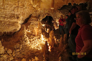
The Caves are privately owned by the Mayfield Family, who are doing a very good job in protecting these natural caverns.  The temperature in the cave is a pretty steady 82 degrees, but the humidity runs about 98%. When you're done walking the last 355 feet up out of the caves, you're perspiring pretty good.  The stalagmites and stalactites near the entrance have died, but shortly after entering, we were soon amazed at the formations below the surface. Some of the passageways are a little narrow but easily passable.
There has been some vandalism inside the caves, and a unique butterfly shape formation was destroyed.  But the 1 1/2 hour tour was well worth the price of admission.
     We had a great visit, got a few repairs down to Big Red, and on Saturday we bid farewell to our hosts and headed south to Mission, TX to begin an earnest search for warmer weather.


     Earlier this winter, I had stumbled onto a blog describing a retirement community in Mission, TX that was building RV sites with casitas and port homes.  They are designed to allow the RV traveler the opportunity to have a little more than a 'campsite", when in Mission, but just lock the door, and you're quickly on your way again. They also offered 3 free nights of camping for coming and looking the place over.  We had to sit through a sales pitch, but there was no pressure, and the program had some definite possibilities.  
 We arrived at Retama Village on Sunday, and were escorted to a lovely site, complete with a 12X24 casita.  The buildings come completely wired and plumbed, but not finished on the inside.  Owners can make them as fancy as they want.  
The Port Homes offer 1 or 2 bedrooms, and the one we visited was about 1100 sq ft.  The 50 foot covered parking space opened up into an outside veranda.  
      Debbie and I both were very impressed with the entire concept.  But the location of this park, and the isolation of being at the southern tip of Texas, was not a location that would work for us. Texas is a darn big state! We also realized that we needed this type of park located near some water.  Other than that, it had just about everything.  If you're looking for a retirement community, follow the link for Bentsen Palms, and drive on down for a visit.  
     Our next stop is South Padre Island, and we arrived there on Wednesday 2/10 at the South Padre Island KOA.  It was a nice easy 80 mile drive over from Mission, TX and we'll be here 12 days.  We're looking forward to some nice warm weather with lots of sunshine.  

Wednesday, February 10, 2016

Escaping Big Bend

     It's been a busy little week, as Debbie and I have worked our way up and down the Texas landscape, taking in all that Texas has to offer.  Up in West Texas, we were up a few feet in altitude, and the weather didn't seem to want to cooperate.  But I'm getting ahead of myself.  We spent our last days in Big Bend touring the west side of the park.  It is a massive park, over 800,000 acres in all. But there are only 3 roads that lead you through the park, and only 2 of those roads lead you out of the park.  Keep that thought in mind for a little later.
The road skirted the Chisos Mountain Range, and led us down to the Rio Grande and a long forgotten military fort at Castolan.  The fort was built to protect the few settlers in the area from cross border skirmishes , but didn't stay very long.  Even today, the NPS abandons the ranger station there during the summer months, because of the unrelenting heat.  Daytime temps regularly soar up to the 120's and ground tempt will actually reach 170 degrees.  There's no reason for anyone to be there.  We passed through some very interesting rock formations getting there, showing the results of volcanic activity millions of years ago.
 When the Rio Grande was rolling, there were farmers in the valley, able to use it for irrigation.  But that was long ago.  There are magnificent cliffs over 1500 feet high, on the Mexican side of the river, showing how powerful the river once was.
      In the distance we could see a pretty significant dust storm coming at us, so we headed back across the park for our campground. As we arrived, the winds were blowing pretty good, and soon we lost power to the campground.
 Not a big deal for me as I have a generator, but with the temps hovering at about 91, a few of the campers would have loved a little A/C.  We soon learned that the wind caused some issues with the electrical wires and up toward Panther Junction there was a pretty good brush fire burning.  Soon, campers from other campgrounds started arriving at ours, having been evacuated from the fire area.
 After speaking with some, and confirming the location of the fire, we discovered that we had no escape route from the fire, since our road out was shut off by the fire.  It sounds worse than it was, but the NPS never advised us of the situation, and rumor control was running rampant through the park.  Our Campground Host even mentioned evacuating across the river in Mexico! Now that would have been exciting.  We survived the night, and in the morning, still with no electricity, and word that the road was open, we decided to make our break out of Big Bend.
As we approached Panther Junction, we could see some pretty high columns of smoke as the fire was still burning, and lots of charred acres alongside the road.  It looks like the NPS was just going to let it burn itself out, as there were no firefighter to be seen.  The following day I sent an email to the Public Information Officer for the Park, letting them know that a little contact with the campers would have been nice.
We went almost 20 hours with no power and a brush fire threatening us, with no information from the NPS.  I got a nice note back saying that those issues would be discussed in the upcoming After Action Brief.  They probably threw it in the trash, but at least I felt better.
      We passed through a Border Patrol checkpoint later on in the day, and I gave one of my baseball cards to the K9 handler working.  He seemed to get a kick out of it.  We spent the night at the Marathon Motel and RV Park in Marathon, which was a nice little overnight park. Best thing was it was a Passport America park, and we stayed for $17.00, which was half off.  Gotta love a bargain!  The girl at the front desk was very friendly, and we met a gentleman who seemed to be fascinated with Big Red.  He gave me his business card showing him involved in the water pump business and claimed to be heading for Guatemala.  You never know who you're going to run into out here on the road.
     Tomorrow we'll be at Randy and Retha's in San Angelo, where we will be treated like a king and queen!  We stiffed them last Fall, as we had business to attend to in San Diego in September.  But they'll be coming through NY next September, and we're putting together a trip down to NYC.  That should be exciting.
     I'm a few days behind with this, but I'm hoping to sit back and enjoy some very nice weather here in South Padre Island.  Traveling like this does tire you out.  Kinda like shoveling snow everyday back home!!!

Tuesday, February 2, 2016

Big Bend National Park


      Well, this is going to be a little experiment to try and save me a little time in the coming days.  We arrived in Rio Grande Village RV near beautiful Boquillas, Mexico yesterday, after Debbie again flashed her America the Beautiful card at the front gate of Big Bend National Park.  We traveled about 22 miles into the Coahilian Desert to our campsite, and after getting all set up, we discovered that there is no cell service or Wi-Fi in the campground.  I could go over to the camp store and use their Wi-Fi, but I’m going to try this experiment first.  I’m going to sit here at my campsite with a nice cold Rondacker, and type my blog in Word without the internet.
      If this works, I’ll drive the other campers nuts, because several have gone by and have seen my typing away, like the internet was sailing by over here at my site.  I’ll try the old cut and paste into my blog after I do get the internet back, and I’ll be right back on schedule instead of days behind.  I’ll import my pictures afterwards, and I should be golden.  Actually, this may prove easier to work with and being “on the line”!
     We arrived yesterday, entering the park just past noon.  We traveled down from Alpine, Tx on Texas Route 118, and it was a very pleasant journey.  There are only 2 ways to get here, the other coming down via Marathon, Tx on Rt. 385.    The volunteer guide at Fort Davis had told me that either route would work, and since I was already camping alongside Rt 118, I didn’t see any point in changing highways.  It was just about 100 miles from The Lost Alaskan to Big Bend Park Headquarters, and we poked along enjoying the sights and sounds of West Texas. 
     Here’s my first tip about camping at the Rio Grande Village RV Park.  When you arrive, you’ll find a wonderful Park sign directing you straight through the intersection if you are going to the “full hookups park”.  Don’t believe it!  We proceeded straight through the intersection as directed, down through the parking lot toward the campground, and just before entering, there was another sign directing us back to the store for “check-in” and “site-assignment”.  The store is located just beyond the intersection we were directed through.  Sure would have been nice to have a 2nd sign, directing us to stop and “check-in”!  Not really a big deal, just a little factoid that may save some other poor soul a trip around the parking lot!
     Since we were camping so close to the Rio Grande, our unprotected border with Mexico, I just had to go down at take a look.  Since Bouquillo, a nice quiet Mexican town, was situated directly across the river, and there was a POE for legally crossing the border, I was sure there would be someone watching the river.  Debbie and I found a great overlook for the river, and within 2 minutes, we observed our first illegal entry into the U.S. from Mexico.  What a treat!  I hadn’t witnessed one of those since 1987.  Yup, everything is secure down here!  We decided to work our way back to camp, and start making our plans for tomorrow’s journey throughout the park.
     Today, we backtracked a few miles, and checked in at the Panther Junction Visitor’s Center.  We’ve found that it’s always a good idea to check the visitor center to ask questions of the Park’s Rangers, or check out the video play in the Center’s theater.  This morning we watched an excellent video describing the Park’s three diverse ecosystems.  Big Bend National Park has the Rio Grande River flowing along 118 miles of its most southern point, and border with Mexico. 
     Everything in this Park is dependent on water, whether it is rainfall or the river.  The Rio Grande has a starting point in Colorado, and flows all the way to the Gulf of Mexico over near Brownsville, Tx.  Pictures on display at the Center show a mighty river flowing through Big Bend in the 1930’s.  There were even farms growing corn, cotton and melons thriving along its banks.  But agricultural demands along its path have drastically impacted the amount of water flowing through today.  Today, there are times when there isn’t enough water to allow paddling down the river.  Visible from our campsite are the magnificent cliffs of Santa Elena Canyon, which has been formed by the erosion of the Rio Grande.  But only half is in the U.S.  The southern most walls tower above the Mexican side of the border, and put on a beautiful display of changing colors as the sun sets each evening.   
    
     The second, and largest ecosystem in the Park is the Chihuahuan Desert.  Today we could see the prickly pear cactus growing pretty much throughout the desert.  But the video explained that the desert comes alive in the spring after just a little rain, and is abundant with color from numerous cacti’s flowers.  Some examples from brochures include the Desert Marigold, Claret Cup Cactus, Desert Willow, Ocotillo, and numerous others.  We’ve also heard stories of the Texas Blue Bonnets that bloom every Spring.  Springtime would be the ideal time to visit this area.  The most unusual aspect of the desert, is the remoteness and tranquility people can experience down here if they wish.  The Park is designed for hiking, not dirt biking, and it is very easy to find yourself all alone in a vast, vast desert setting. 
     In the center of the park is where the entire range of the Chisos Mountains are found.  The peaks of these mountains reach nearly 8000 feet above sea level, and are home to cougars and the Mexican Black Bear.  Douglas Fir, Arizona Pines, and Bigtooth Maple can be seen flourishing at the higher elevations.  The views down to the Chihuahuan Desert from the Chisos Mountains are amazing, and allows visitors to view the expanse of the National Park.

     Tomorrow, we’ll be traveling over to the Western side of the Park, and follow the Chisos Range down to the Rio Grande.  There appear to be numerous lookouts and vistas along the way, and it should be a pretty good trip.